Tuesday, 31 March 2009

Two Sentence Tuesday: 31 March 2009

To prepare for the historical posts I write I read from a variety of sources. Two recently read sentences from “True Canadian Stories of the Great Lakes” by Mark Bourrie are: “There were still enough lifeboats left on the Mary Ward to take all the passengers off, and the waves were so small that they didn’t scare the passengers. The warm late-fall weather, which has caused so much false confidence in so many doomed sailors, lulled the Mary Ward’s passengers and crew back into their bunks.”

From my current dark fantasy WIP, Keeper 2, two sentences I wrote: “Stefan started up the narrow path, Maggie behind him, scrambling over the loose scree at the bottom. About a third of the way up it stopped in a badly eroded area, one side sheet rock, the other dropping off into space.”


For other participants to Two Sentence Tuesday visit Women of Mystery.

Tuesdays For Travis - Cranberry Portage

[1-click to enlarge]

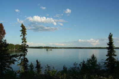
Cranberry Portage is located 48km south of Flin Flon, and 695 km north-west of Winnipeg, Manitoba. It is situated along the southern shores of Lake Athapapuskow, surrounded by lakes, rivers and streams in the western portion of the Grass River Provincial Park .

[2] Prior to 1928, it was little more than a portage route used by fur traders and First Nations people, known for its abundant beautiful lakes with excellent fishing and scenic landscapes. Cranberry Portage was an important trade route of the Cree and Assiniboin peoples during the fur trade, its location used as a campsite and portage between Grassy River at the head of a number of well-used routes from Hudson Bay and Lake Athapapauskow, which connects to the Saskatchewan River system leading through the prairies to the foothills of the Rocky Mountains.

The area is known for trophy fishing of northern pike, walleye, lake trout, rainbow and brook trout, white fish and tubilee.


[3-click to enlarge]


Sources:
http://www.norman-rha.mb.ca/CranberryPortage.htm
http://en.wikipedia.org/wiki/Cranberry_Portage,_Manitoba

Photo Credits: [1][2][3]-brianwestcott CC=nc-nd-flickr.

Sunday, 29 March 2009

My Town Monday - Toronto Island Ferry Service

[Entrances to the passenger wharves on the Toronto Waterfront in 1894 - click to enlarge]


Before the Toronto Islands were islands it was a peninsula attached by a narrow neck of land at Cherry Street. The local First Nations used the peninsula for restorative purposes. Michael O’Connor owned the first ferry in 1833 named ‘Sir John of the Peninsula’ and charged his customers 7 1/2 cents per trip to and from the Island. George Heathcote expanded on the idea with his steam ferry which ran from 1835 to 1851.

In 1843, Peter and Louis Privat purchased the Peninsula Hotel on the island, added an amusement park and small zoo, and to bring paying guests over they advertised trips across the Bay on their horse-powered ferry. These ferries were sixty feet in length with paddle wheels on either side of their hulls. The paddle wheels were turned by the efforts of horses moving a treadmill to which clockwise gears were connected.

The Privat Brothers had competition in their hotel business when Reubon Parkinson, a carriage builder, built a hotel on Maskelonge Point (now Mugg’s Island). When their businesses conflicted too often, Parkinson moved his dwelling eastward and located it upon the sandy neck of land connecting the Peninsula with the mainland. A severe storm in 1858 washed away his hotel and created the Eastern Gap.

The year 1851 brought more steam-powered ferries to the Bay Ferry terminus which outran the horse-boats effectively putting them out of business.

[ In 1856 the steamer, The Monarch, became stranded in ice just off the Islands]

The first moonlit cruises were started in 1861.


[The Cibola in 1887]

The Cibola built in the early 1880s to ferry passengers from Toronto to certain points on Lake Ontario was destroyed in a fire in 1895 at the Lewiston Dock on the Niagara River. The Cibola’s three-part chime whistle was placed on the Corona, constructed in 1896 as a replacement.

After 1882 the ferries were constructed to carry larger crowds to the Islands. In 1890 the Toronto Ferry Company came into existence with fourteen ferries, one being The Mayflower. This two-decked paddle wheeled ferry was licensed to carry 1,000 passengers, and carried the novel distinction of new electric lights. The Mayflower continued the ferry runs for 53 years before being retired and stripped into a barge to haul garbage to the Inspector Street incinerator.

According to Wikipedia: “In 1906 and 1910, the Toronto Ferry Company built two sister ships, both being double-decked double-ended paddle steamers, with a capacity of 1450 passengers. They were named Bluebell and Trillium. They were retired in 1955 and 1957 respectively, but Trillium survived and re-entered service in 1976. She is still in service and is operated by the Great Lakes Schooner Company for Corporate functions and Private Functions, as well as ferry runs throughout the summer.”

[Trillium - click to enlarge]

The ferry service continued to operate until April 1926 with decreasing patronage and poor equipment. That year the City purchased the ferry fleet and assorted buildings in L.J. Solomon’s ownership on the Island.

The Toronto Transportation Commission took over operation of the ferry service on April 15, 1927 and found the vessels were in need of immediate repairs, the Hanlon Point Docks were so unsafe that there was no guarantee that any boat tied up to it wouldn’t pull it off its moorings. New ferry docks were constructed at the foot of Bay Street with the Bay and Dupont streetcar lines extended to them. These were replaced later by the Bay bus route. In the early 1970s the new Queen’s Quay docks were located just east of the old ones.

An earlier post on the Toronto Islands provided bits of history and how the islands were developed over time can be seen here.

Photos and further information on the ferry service and the boats can be seen in the links listed in the sources.

Sources:
http://www.angelfire.com/ca/TORONTO/history/island1890.html
http://www.angelfire.com/ca/TORONTO/history/islandbegin.html
http://www.angelfire.com/ca/TORONTO/history/island1918.html
http://www.angelfire.com/ca/TORONTO/history/islandmunicipal.html
http://en.wikipedia.org/wiki/Toronto_Island_Ferry_Services


Photo Credits: wikipedia

Travis Erwin from Amarillo, Texas is the founder of My Town Monday. For other locations to visit please go to Travis' site here.

Saturday, 28 March 2009

Exploring New Frontiers


At one time explorers who sailed the Atlantic Ocean to the New World were embarking on a dangerous journey into unknown territory. They were followed by men who sought the North and South Poles. Space travel by private citizens was only dreamed about.

Today U.S. billionaire tourist, Charles Simonyi, on board a Soyuz capsule carrying a Russian cosmonaut, Gennady Padalka, and an American astronaut, Michael Barratt, docked at the International Space Station. This is Simonyi’s second trip as a paying customer to the space station. He will be returning to Earth on April 7 with cosmonaut, Yuri Lonchakov, and NASA astronaut, Michael Fincke. Any future trips will be put on hold as the space station’s permanent crew is expanding from three to six.

It is only a matter of time before other private citizens will be taking space trips.


Source: Canadian Press

Photo Credit: wikimedia commons

Friday, 27 March 2009

Baron Canyon


With the days becoming sun filled and warmer I think about the summer days of going on hikes over the surrounding trails. On any walk I prefer locations which have water: a lake, a stream, creek or river, preferably a waterfall. The sound of rushing water is soothing to urban tortured souls.

Baron Canyon is in Algonquin Provincial Park which I have posted about before here.

Photo Credit: eyeline-imagery CC=nc-nd-flickr.

Thursday, 26 March 2009

Hiking Trails - Beaver Creek

Today's hike is an amble on one of the five trails at Beaver Creek Conservation Area.


[1-Banks of Beaver Creek]


Beaver Creek Conservation Area is located 13 km south of Saskatoon, Saskatchewan. It is a sheltered creek and part of the microcosm of the Meewasin Valley, containing one of the few uncultivated short-grass prairie sites in Saskatchewan. There are five self-guided nature trails in this location. “Meewasin” is the Cree word for ‘beautiful’.


[2-Wild Bergamot]


[3-Prairie Coneflower]


[4-Beaver Creek is low for June]


[5-Staircase down to ravine bottom]


[6-Dotted Blazing Star appear July to August]


[7-Bridge near visitor centre]


[8-Prairie Sunflower]


[9]


[10-Beaver Creek]


[11-Wavy Leafed Thistle with wild oats - click to enlarge]


[12]


[13-Parting shot of Beaver Creek - click to enlarge]


For information and an aerial view on Beaver Creek in the Meewasin Valley go here and here for programs.

Photo Credits: [1][2][3][4][5][6][7][8][9][10][11][12][13]-Daryl Mitchell CC=nc-sa-flickr.

Wednesday, 25 March 2009

Willow Bunch

[click to enlarge]

Willow Bunch is prime cattle country in southern Saskatchewan. The town was established in 1870 and is forty minutes from the Canada-U.S. boundary. Its first settlers were three groups of Metis hunters from Manitoba who wintered here in 1870. They were soon joined by Jean-Louis Legare, a fur trader, and an Oblate Missionary, Rev, Jean-Joseph Lestanc O.M.I.


[slick to enlarge]


Source: willowbunch.ca

The Jesuits - Joseph Le Caron

The Recollets, the first priests to come to New France in 1615, brought their ambition to convert North America’s native people.*

[Honfleur Harbour]

Joseph Le Caron (1586, near Paris—March 29, 1632, France) was one of the four Recollets, the first priests to come to New France in 1615 with Samuel de Champlain, (together with Father Denis Jamet, their first Superior, Father Jean D’Olbeau, and Brother Pacifique du Plessis), and the first missionary to the Hurons. On April 24, 1615, they sailed from Honfleur [photo] aboard the St. Étienne. Le Caron reached Tadoussac on May 25 where his garb perplexed the Indians: “a form of what was common to the brotherhood of Saint Francis, consisting of a rude garment of coarse gray cloth, girt at the waist with the knotted cord of the Order, and furnished with a peaked hood, to be drawn over the head. His naked feet were shod with wooden sandals, more than an inch thick.”Δ In a few days Le Caron accompanied some fur-traders to Saint-Louis rapids, to meet the Hurons there and attempt to follow them into their own country.


[Lake Huron shaded]

He was the first to visit their settlements and preach the Gospel by making the 1,100-km voyage following the Ottawa River as far as the Mattawa, the Mattawa as far as Lake Nipissing, and then the French River to Georgian Bay. He was the first European to see Lake Huron [photo], which he reached by the end of July, a few days before Champlain arrived. On August 12, 1615 he celebrated the first mass in Huron country, in the presence of Champlain. Le Caron stayed with the Hurons about a year (1615-16), and was again among them in 1623, accompanied by Father Viel who contributed significantly to Le Caron’s dictionary of the Huron language and Brother Gabriel Sagard. He was also compiling dictionaries of the Algonkin and Montagnais languages. At that time he evangelized the Montagnais of Tadousac and taught them to read and write.

The best known of these, Gabriel Sagard, made only one return voyage into the Upper Country, in 1623-1624. His account, Le Grand Voyage du pays des Hurons […], became an indispensable work about the Huron people. Sagard's voyage did not contribute to the expansion of New France, but the information that he gathered from the Native peoples on far-away areas helped other voyagers. Among other things, he wrote the first phrasebook of the Huron language.


Voyage through the forest:
"On a aussi quelquefois bien de la peine à se faire passage avec la tête et les mains parmi les bois touffus, où il s'y en rencontre grand nombre de pourris et tombés les uns sur les autres, qu'il faut enjamber, puis des rochers, des pierres et d'autres incommodités qui augmentent le travail du chemin, outre le nombre infini de moustiques qui nous faisaient incessamment une très cruelle guerre; et n'eût été le soin que je portais à me conserver les yeux par le moyen d'une étamine que j'avais sur la face, ces méchants animaux m'auraient rendu aveugle beaucoup de fois; et ainsi en était-il arrivé à d'autres qui en perdirent la vue pour plusieurs jours, tant leur piqûre est venimeuse à l'endroit de ceux qui n'ont encore pris l'air du pays."
(Sagard 1669, 44-45)

[trans.]
”Sometimes also one has great difficulty in making a passage with head and hands through dense woods, in which also a great number of trees that have rotted and fallen on one another are met with, and these one must step over. Then there are rocks and stones and other obstacles which add to the toil of the trail, besides the innumerable mosquitoes which incessantly waged most cruel and vexatious war upon us; if it had not been for my care in protecting my eyes by means of a piece of thin stuff which I had covering my face, these fierce creatures would have blinded me many times, as I had been warned. It had happened so to others, who lost the use of their eyes for several days, so poisonous is their stinging and biting to those who have not yet become acclimatized.”
(Sagard 1939, 63)

In 1625 Le Caron was once more in France, returned to Canada a year later, was elected superior of his order at Quebec, and filled this office until the capture of Quebec by the English in 1629, when he and his colleagues were sent back to France by the conquerors.

Le Caron died of the plague in the convent of Ste.-Marguerite in France, where he was superior, on 29 March 1632, 46 years old, the very day the Treaty of Saint-Germain-en-Laye was signed which restored Canada to France . The Collège Édouard-Montpetit in Longueuil, Quebec has a pavilion named in his honour.


Source: http://en.wikipedia.org/wiki/Joseph_Le_Caron
http://www.biographi.ca/009004-119.01-e.php?BioId=34481
http://oce.catholic.com/index.php?title=Joseph_Le_Caron
*The Illustrated History of Canada, edited by Craig Brown p.106
Δ The Pioneers of France in the New World

Tuesday, 24 March 2009

Two Sentence Tuesday: 24 March 2009

These depressing sentences are what I recently read from “Feds to test taps for cancer contaminants” by the Canadian Press at the time of my own tap water scare which remains ongoing, at least until I receive the water test results:

“Health Canada is now seeking a contractor to determine if the contaminants, known as disinfection byproducts, flow from the country's taps. Water-treatment plants have long used disinfectants such as chlorine and ozone to eliminate bacteria from drinking water. But in the 1970s, scientists discovered the disinfectants react with organic materials in untreated water, such as decaying vegetation, to form the byproducts.”

And for those readers who seem unable to withstand suspense of my usual two sentences, today here are several from my WIP ‘Keeper 2’:

“A flash of reflected light in the corner of Alicia’s left eye made her look. The blade of a long sword moved quickly slicing through air. The creature reared up on hind legs, roared, part of pain, part of anger as the sword slashed through its neck; and in the return arc entered mid-chest. The roar became a gurgle, and the huge furry mass toppled back.”

For other participants to Two Sentence Tuesday visit Women of Mystery here

Tuesday for Travis - Oxbow Lake

[Oxbow Lake - click to enlarge]


The view in this photo is looking north on the small oxbow lake on the Assiniboine River at Spruce Woods Provincial Park. The park is south-east of Brandon, Manitoba or 170 km west of Winnipeg.

For families the campground at this location has a nice beach for younger children. The park has well developed facilities including a snack bar, mini golf, hiking trails, cycling trails, horse riding, horseshoes, orienteering courses, canoe and paddle boat rentals.


Source: Spruce Woods Provincial Park , Manitoba

Photo Credit: Ted Sali CC=nc-nd-flickr.

Sunday, 22 March 2009

My Town Monday - Toronto, Then and Now


[Facing north on Spadina toward College - click to enlarge]


Victorian drinking foundation for humans, dogs and horses taken in April 1899, and below April 2008. Note the boy is collecting water in a cup.


[Queen and Spadina intersection - click to enlarge]


At the intersection of Queen and Spadina Streets, the building with the ugly Aldo billboard is the survivor on this corner. One wonders why they demolish a building for what now houses a MacDonald's franchise. By looking closely at the lower middle of the top photo, you can see a stairwell descending into one of Toronto’s now long gone public toilets.


Photo Credits: James Boston CC=nc-sa-flickr.

Travis Erwin from Amarillo, Texas is the founder of My Town Monday. For other locations to visit please go to Travis' site here.

Thursday, 19 March 2009

Hiking Trails - Radium Lake Trail


[1-Trail sign to Mt. Webb and Radium Lake - click to enlarge]


This trail is located 150 miles east of Vancouver, British Columbia in the Upper Chilliwack Valley at Chilliwack Lake Provincial Park encompassing 9,258 hectares.

The Hudson Bay Company cut the first recorded trail up the Chilliwack River in 1855, improving the Indian Trail which joined the nine Indian villages between Vedder Crossing and Chilliwack Lake.

The Radium Lake trailhead (16 km return) is accessible from the Chilliwack Lake campground which will take about 4 hours with an elevation gain of 910 m.

Park users should always be aware of bears and other wildlife.


[2-This bridge was closed but the hikers persevered by going on]


Second bridge is a wire cable suspension bridge – this bridge has now been removed.


After the bridge the trail becomes steeper.


[3-Gray Jay - click to enlarge]

The Gray Jay (Perisoreus Canadensis) is larger than a big chickadee. It is 11.5 inches long ranging in mountain forests and woodlands close to campsites. A bowl shaped nest of twigs lined with feathers and hair is built up to 30 feet in a tree. It lays 3 to 5 green-gray spotted eggs, which the female incubates for 17 to 18 days. The young leave the nest two weeks later with juvenile birds a darker gray all over, with a whitish mustachial streak.*


In another 2.5 km the creek is crossed again.

On the other side is an old cabin site.

Further on in a half a kilometre the creek appears again.


[4-Radium Lake - click to enlarge]


[5-Looking at the col - click to enlarge]


At the north end of the lake is an old service cabin.

Be warned there are loads of mosquitoes present.


[6-Radium Lake - click to enlarge]


You can also continue past Radium Lake for a 45 minute hike on a good trail up to the col between Mt. Webb on your left and Mt. MacDonald on your right.


[7-Two hikers scrambling up a gulley to the Macdonald-Webb Col - click to enlarge]


[8-Mt. Webb - click to enlarge]

Mt. Webb is 2164 m in height.


Sources: Chilliwack Lake Provincial Park
Map of trail to Radium Lake and Mt. Webb
*A Field Guide to the Birds of North America by Michael Vanner, p.166

Photo Credits: [1][2][4][5][6][7][8]-Iwona Kellie CC=flickr, [3]-m d d CC=nc-sa-flickr.

Tuesday, 17 March 2009

Irish Within


Camus House is ivy covered which dates back to 1685 and is built on the old Camus Monastery near Coleraine, Northern Ireland. The property is near the Bann River. This particular house is where my great-grandfather, Joseph Martin, and his brother, James McCardie Martin, D.S.O., were born. For years I was under the impression they had been born in England. It's nice to know I have more than a mere sliver of Irish in my blood; though my grandmother did tell me I had the eyes of the 'Black Irish'.

Its unfortunate I had not planned on this post, as I have two nice photographs of Uncle Jim, one in his naval uniform with the typical surgeon's beard, and one with his grey heavy hunter.

For those of Irish descent or well wishers, I hope you all had a grand St. Patrick's Day.


Source: Coleraine Historical Society
Photo Credit: Discoverireland.com

Two Sentence Tuesday: 17 March 2009

This week I have been reading “When Gods Die” by C. S. Harris, a Regency mystery of wonderful historical description and sleuthing. The last two sentences I read were: “Tom hopped down, his eyes flashing. “You mean something big enough to hide a body in?” "

My two sentences are from a work-in-progress dark fantasy, Keeper 2, and are in first draft stage: “Usually Maggie loved the wilderness, the free expanse of land and sky, but now she felt the hills and the forest thick with trees, deadfall and bushes were oppressive. The dim light filtering through the tree tops and constant curving of the narrow dirt path played havoc with her sense of direction."

For other Two Sentence Tuesday participants please visit Women of Mystery.

Monday, 16 March 2009

My Town Monday - Great Fire of Toronto 1904


The Great Toronto Fire of 1904 destroyed a large section of downtown Toronto, Ontario, on April 19, 1904.

The fire was first spotted at 8:04 p.m. by a constable on his regular street patrol. The flames were rising from the elevator shaft of the Currie neckwear factory at 58 Wellington Street West, just west of Bay Street. The factory was located in the centre of a large industrial and commercial area. The exact cause of the fire was never determined.

The fire began on the evening of the 19th and took nine hours to get under control. The glow of the fire could be seen for kilometres in all directions. Firefighters from cities as far away as Hamilton, Ontario and Buffalo came to Toronto's aid. The battle was made more difficult by strong winds and sub-zero temperatures. The temperature that night was approximately -4 degrees Celsius (24F) with winds at 48 kilometres per hour with snow flurries.


The fire destroyed 104 buildings on about twenty acres of land, but killed no one. It caused $10,350,000 in damage and put five thousand people out of work, at a time when the city only had 200,000 inhabitants. As a result of the fire, more stringent safety laws were introduced and an expansion of the city's fire department was undertaken.

It was the largest fire ever in the city, although a previous large fire had consumed many city blocks on April 7, 1849 when the city was much smaller and constructed mostly with wood.


[Front Street]


The legacy of this fire includes Call Box 12, which was used to sound the alarm and now is the name for the volunteer canteen truck supporting Toronto Fire Services today.


Sources:
http://en.wikipedia.org/wiki/Great_Toronto_Fire
http://www.archives.gov.on.ca/english/exhibits/fire/index.html

Photo Credits: wikipedia.

Travis Erwin from Amarillo, Texas is the founder of My Town Monday here.
As Travis is moving house this week, for other locations to visit please go to Jenn Jilks' site here while she temporarily holds the reins.


Friday, 13 March 2009

Your Blog is Fabulous


Mihai from Dark Wolf’s Fantasy Reviews has nominated me for this award. He must like crossing the pond to visit the virtual vistas presented herein.

Part of accepting the award is to point out 5 things I am obsessed with and cannot live without. There are many other bloggers whom I would like to know the five things they are obsessed with, but can only choose 5. Drat!

My 5 obsessions are:

1. The current dark fantasy stories I have been writing and compiling backstory on for the past several years.

2. Books in different genres, without which I would be hard pressed to be inspired to write intriguing bits that fit.

3. Organic coffee from the Birds and Beans store in Toronto. I live for my freshly brewed coffee in the morning and evenings.

4. Environment, preferably the Canadian Rocky Mountains, which my frequent posts attest to.

5. Heineken Beer, sometimes used to attract aliens here
or spies here


My 5 nominated bloggers are:

1. Shauna Roberts of For Love of Words ;

2. David Cranmer of The Education of a Pulp Writer ;

3. Reya Mellicker of The Gold Puppy ;

4. Gabriele of Lost Fort;

5. Barrie Summy, writer of teen books.

For those who do not wish to pass on the award, I understand; however, in the interest of good clean fun, please participate by providing your list of obsessions.

Thursday, 12 March 2009

Hiking Trails - Tunnel Mountain

Tunnel Mountain is located near Banff in Banff National Park, Alberta.

Today's hike has an elevation gain of 300 metres. It has been many years since I've been on this trail, but the only change from my youth is the fire tower has been removed.

4.3 km (2.7 miles) round-trip 2 – 3 hours


[1 - Tunnel Mountain taken from Sulphur Mountain - click to enlarge]


In 1858, James Hector named this small peak: The Hill. In 1882, Major Rogers planned to construct a tunnel through this mountain for the railway line, not realizing he could easily avoid the problem of the cliffs above the Bow River by following the Cascade River and going north of The Hill. When CPR General Manager William Van Horne saw Rogers' plans he was furious. "Are we going to hold up this railway for a year and a half while they build their damned tunnel? Take it out!" So the tunnel was never built, but the mountain name commemorates Rogers' intended folly.*

The St. Julien Road trailhead can be reached by turning east off Banff Avenue via Moose or Wolf Street. Shortly after passing the angled junction to Grizzly Street turn left (uphill) to the parking lot with the trail sign (just north of the Banff Centre).


[2- Tunnel mountain trail]


At 0.4km the trail crosses the Tunnel Mountain Road

Above the road there are a series of long switchbacks that provide a gradual ascent through a forest of lodgepole pines and Douglas firs.


[3 - south-west view looking over Banff townsite and Sulphur Mountain]


There will be occasional glimpses of the Town of Banff and Bow Valley.


[4- wildflower - click to enlarge]


[5- Deer encounter on trail - click to enlarge]


[6- Encounter on the trail - click to enlarge]


[7- Younger buck on trail - click to enlarge]


[8- click to enlarge]


[9]


[10-Juniper berries - click to enlarge]


[11-view west Bow River Valley - click to enlarge]


[12 - click to enlarge]


[13 - Trail - click to enlarge]


[14 - Banff townsite and Bow River - click to enlarge]


[15 - south-west view of Banff and Sulphur Mountain, line across is road to Upper Hot Springs and the Gondola Cable Car Station - click to enlarge]


[16 - Tunnel Mountain Trail - click to enlarge]


[17- View west over Bow River Valley and Sulphur Mountain on left- click to enlarge]


[18- View north-east over Bow River Valley - click to enlarge]


[19- View south in Spray River valley from trail, Suphur Mountain on right - click to enlarge]


[20-Crocus on trail - click to enlarge]


[21- wildflower on Tunnel Mountain Trail -click to enlarge]


[22- View west of Banff townsite, Bow River Valley and Vermilion Lakes- click to enlarge]


[23- View south-east toward Mt. Rundle and Banff Springs Hotel Golf Course - click to enlarge]


The (Fairmont) Banff Springs Hotel has a 27-hole championship golf course.


[24-View east of Bow River Valley - click to enlarge]


[25]


[26-view north-east]


[27-View east of Bow River Valley, Mt. Rundle and Banff Springs Hotel Golf Course - click to enlarge]


[28]


[29- Near summit of Tunnel Mountain - click to enlarge]


[30- View west over Banff townsite, Bow River Valley and the Vermilion Lakes - click to enlarge]


There are limestone slabs near the summit.


On the summit ridge, the trail doubles back and runs above Tunnel Mountain’s east facing cliffs.

Trail ends at 1,690 m at the site where there had been a fire lookout tower once named ‘King’s Lookout’ after King George VI and Queen Elizabeth hiked there in 1939.

Stoney Indian Noah Cecil said his grandfather helped carry a dying tribesman atop Tunnel Mountain, and erect a teepee for his departing spirit, commenting, "A man's a long time dead. On mountain he see more." (Harriet Hartley Thomas, From Barnacle to Banff)


[31-Summit of Tunnel Mountain]


Sources: ParksCanada
*http://rmbooks.com/books/tunnel.htm

Photo Credits: [1][21]-ocad123 CC-nc-nd-flickr, [2][3][5][6][7][8][9][10][11][12][13][14][15][17][18][19][22][23][24][25][26][27][28]-diluvienne CC=nc-flickr, [4]-ronsipherd CC-nc-nd-flickr, [16]-Graingraf CC=nc-nd-flickr, [20]-djking CC=nc-sa-flickr, [29]-cicadas CC=nc-sa-flickr, [30][31]-el capitan CC=nc-sa-flickr.